A. Global Positioning System (GPS):
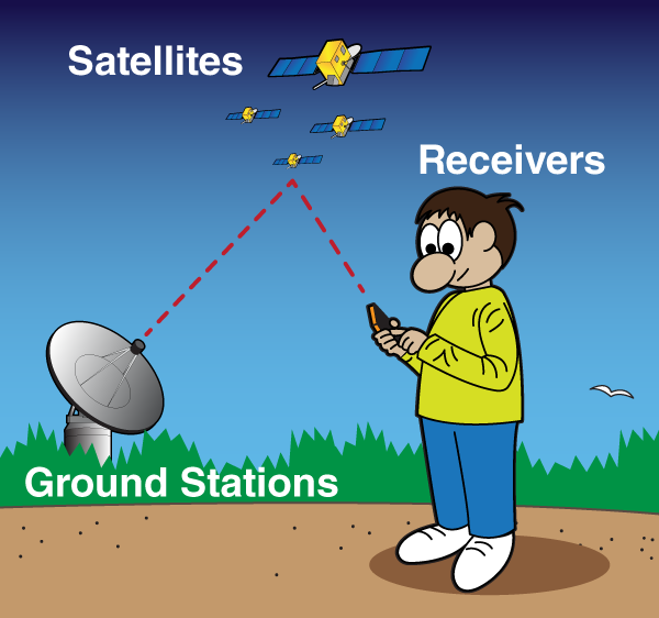
- It is a set of 24 satellites in the Earth orbit. It sends out radio signals that can be processed by a ground receiver to determine the geographic position on earth.
- Global Positioning System satellites broadcast signals that allow GPS receivers to calculate their position.
- This information is provided in real time, meaning that continuous position information is provided while in motion.
- Having precise location information at any time allows soil and crop measurements to be mapped.
- GPS receivers, either carried to the field or mounted on implements allow users to return to specific locations to sample or treat those areas.
- It has a 95% probability that the given position on the earth will be within 10-15 meters of the actual position.
- GPS allows precise mapping of the farms and together with appropriate software informs the farmer about the status of his crop and which part of the farm requires what input such as water or fertilizer and/or pesticides etc.
- Uncorrected GPS signals have an accuracy of about 300 feet.
- To be useful in agriculture, the uncorrected GPS signals must be compared to a land based or satellite based signal that provides a position correction called a differential correction.
- The corrected position accuracy is typically 63-10 feet.
- When purchasing a GPS receiver, the type of differential correction and its coverage relative to use area should be considered.
B. Geographic Information System (GIS)
It is software that imports, exports and processes spatially and temporally geographically distributed data
C. Grid Sampling:
- It is a method of breaking a field into grids of about 0.5-5 hectares. Sampling soil within the grids is useful to determine the appropriate rate of application of fertilizers.
- Several samples are taken from each grid, mixed and sent to the laboratory for analysis.
D. Variable Rate Technology (VRT):
- The existing field machinery with added Electronic Control Unit (ECU) and onboard GPS can fulfill the variable rate requirement of input.
- Spray booms, the Spinning disc applicator with ECU and GPS have been used effectively for patch spraying.
- During the creation of nutrient requirement map for VRT, profit maximizing fertilizer rate should be considered more rather than yield maximizing fertilizer rate.
E. Yield Maps
- Yield maps are produced by processing data from adapted combine harvester that is equipped with a GPS, i.e. integrated with a yield recording system.
- Yield mapping involves the recording of the grain flow through the combine harvester, while recording the actual location in the field at the same time.
F. Remote Sensors:
- These are generally categories of aerial or satellite sensors.
- They can indicate variations in the colours of the field that corresponds to changes in soil type, crop development, field boundaries, roads, water, etc.
- Arial and satellite imagery can be processed to provide vegetative indices, which reflect the health of the plant.
G. Proximate Sensors:
- These sensors can be used to measure soil parameters such as N status and soil pH) and crop properties as the sensor attached tractor passes over the field.
H. Computer Hardware and Software:
- In order to analyze the data collected by other Precision Agriculture technology components and to make it available in usable formats such as maps, graphs, charts or reports, computer support is essential along with specific software support.
I. Precision irrigation systems:
- Recent developments are being released for commercial use in sprinkler irrigation by controlling the irrigation machines motion with GPS based controllers.
- Wireless communication and sensor technologies are being developed to monitor soil and ambient conditions, along with operation parameters of the irrigation machines (i.e. flow and pressure) to achieve higher water use efficiency
J. Precision farming on arable land:
- The use of PA techniques on arable land is the most widely used and most advanced amongst farmers. CTF (contolled Traffic Farming) is a whole farm approach that aims at avoiding unnecessary crop damage and soil compaction by heavy machinery, reducing costs imposed by standard methods.
- Controlled traffic methods involve confining all field vehicles to the minimal area of permanent traffic lanes with the aid of decision support systems.
- Another important application of precision agriculture in arable land is to optimize the use of fertilizers especially, Nitrogen, Phosphorus and Potassium.